Description
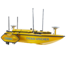
Introducing the CHCNAV Apache 6
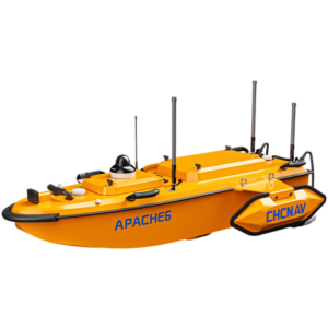
The CHCNAV Apache 6 is an advanced Unmanned Surface Vehicle (USV) designed for high-resolution 3D bathymetric surveys and underwater object positioning. Its robust triple-hull design ensures stability and adaptability in various marine environments. Equipped with a high-performance dual propeller system, it maintains a consistent automatic cruise speed, enhancing survey efficiency. The Apache 6 supports optional Norbit multibeam echosounders and iLiDAR scanners, enabling precise data collection for offshore construction and underwater archaeology. Its autonomous operation, powered by CHCNAV’s accurate straight-line technology, allows it to follow predetermined paths even in challenging current conditions. The user-friendly Android remote control extends operational flexibility, with a control range of up to 2 km. With a draft of just 12 cm, it is suitable for shallow water operations. The Apache 6’s versatility makes it an ideal solution for complex marine survey projects.
Features
| Feature | Description |
|---|---|
| Multifunctional USV Platform | Supports optional Norbit multibeam echosounders and iLiDAR scanners for accurate 3D bathymetric surveys. |
| Autonomous Operation | Follows predetermined paths using CHCNAV’s accurate straight-line technology, ensuring consistent data quality. |
| Superior Powertrain | High-performance dual propeller system ensures stable automatic cruise speed up to 2.5 m/s. |
| Android Remote Control | User-friendly interface with a control range of up to 2 km, enhancing operational flexibility. |
| Shallow Water Capability | Draft of 12 cm allows operations in shallow waters. |
Versatile USV Platform
Conduct precise 3D bathymetric surveys using optional Norbit multibeam echosounders and iLiDAR scanner. Gather high-resolution data to enhance the accuracy of underwater object positioning and offshore construction projects.


Independent Surveying
Navigate predefined paths with CHCNAV’s precise straight-line technology. Carry out surveys autonomously, maintaining consistent data quality even in challenging current conditions.
Wide-Ranging Survey Capabilities
Perform offshore, coastal, and inland water surveys with the Apache 6’s adaptable design. It is engineered to meet the challenges of even the most demanding hydrographic survey projects.


Stable Tri-Hull Design
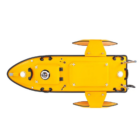
The Apache 6’s triple-hull structure and removable side floats provide enhanced stability and adaptability, ensuring optimal performance even in fast-moving currents.
Smart Android Remote Control
Collect and display data in real-time through 4G and 2.4 GHz communication via the Android remote control. Ensure uninterrupted connectivity and reliable data transmission for enhanced operational efficiency.

Use Cases
Dredging Operations
The Apache 6 provides precise data for dredging projects, helping map seabed contours and optimize dredging activities, ensuring efficient removal of material.
Port Surveys
It supports detailed port surveys, enabling accurate mapping of underwater features, currents, and hazards to enhance port safety and operation efficiency.
Bridge and Dam Inspections
The Apache 6 is ideal for inspecting submerged structures such as bridges and dams, offering high-resolution data to assess their condition and ensure structural integrity.
Underwater Pipeline and Cable Inspection
It facilitates the inspection of underwater pipelines and cables, providing accurate positioning and detailed imaging to detect potential issues or damages.
Specifications
| Category | Specification |
|---|---|
| Performance | |
| Speed max | 5 m/s |
| Payload capacity | Up to 60 kg |
| Draft | 18 cm |
| Positioning | Full GNSS + IMU |
| Echosounder | |
| Type | Single beam, 200 kHz |
| Range | 0.15 to 200 m |
| Resolution | ±0.01 m + 0.1% x D |
| Sensors | |
| Camera | 360° video |















There are no reviews yet.