
Description
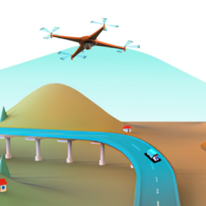
Drone Mission Ops
Companion app for Drone Planning and Operations
Drone Mission Ops is an advanced software platform designed to optimize drone mission planning, execution, and data analysis. It offers automated flight control, precision data capture, and real-time telemetry, ensuring efficient and reliable operations. With seamless integration, enhanced safety protocols, and comprehensive support, Drone Mission Ops is ideal for professional applications in agriculture, construction, public safety, and environmental monitoring, providing the tools needed for precise and effective drone missions.

Advanced Mission Planning: Intuitive drag-and-drop interface for easy mission setup, automated route creation for optimal coverage, and geo-fencing capabilities to define and avoid no-fly zones and restricted areas.
Autonomous Flight Control: Pre-programmed flight modes for hands-free operations, real-time GPS navigation for accurate positioning and routing, and intelligent obstacle detection and avoidance for safe flight paths.
Precision Data Capture: High-resolution imaging and video capture for detailed analysis, integration with multi-spectral and thermal sensors for diverse applications, and real-time data transmission for immediate analysis and decision-making.
User-friendly Interface: Comprehensive dashboard for streamlined mission management, real-time flight telemetry and status updates for situational awareness, and easy-to-use controls suitable for both novice and experienced pilots.
Seamless Integration: Compatibility with a wide range of drone hardware platforms, robust API support for third-party software integration, and support for industry-standard data formats to ensure easy interoperability and extended functionality.
Enhanced Safety Protocols: Automated emergency landing protocols and fail-safes for risk mitigation, continuous battery health monitoring with proactive alerts, and real-time weather condition assessments and alerts to maintain safe flight operations.
Data Analytics and Reporting: Advanced analytics tools for in-depth data analysis, secure data storage with easy retrieval and sharing options, and detailed reporting features for comprehensive post-mission review and documentation.
Collaboration and Team Management: Multi-user access with customizable role-based permissions for efficient team collaboration, secure cloud-based data sharing for real-time mission planning and execution, and real-time coordination with ground teams and control centers.
Comprehensive Support: Regular software updates and feature enhancements to keep your operations up-to-date, detailed user guides and tutorials for effective self-learning, and dedicated customer support for prompt assistance and troubleshooting.
Industry-specific Solutions: Tailored applications for agriculture (precision farming, crop monitoring, yield estimation), construction (site surveying, progress tracking, material management), public safety (search and rescue, disaster assessment, traffic monitoring), and environmental monitoring (wildlife tracking, pollution detection, habitat mapping).
Drone Mission Ops provides the tools needed for efficient, safe, and precise drone mission execution, elevating operations across various professional fields.
Elevate Your Drone Operations with DMO
Drone Mission Ops is a robust drone operations solution that automates and refines drone flights. It ensures precision, safety, and efficiency, making it ideal for professional applications across agriculture, construction, public safety, and environmental monitoring.


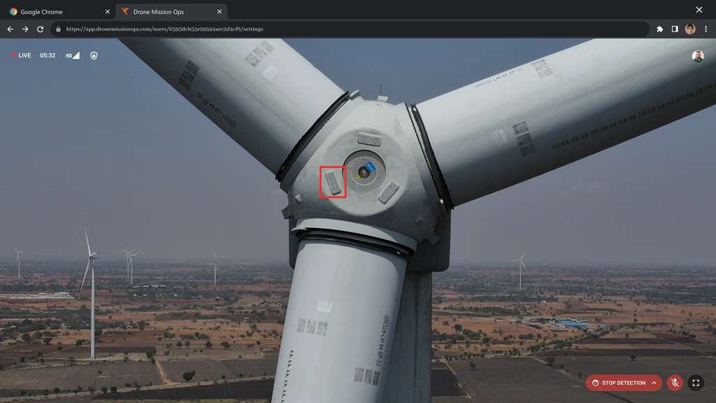
Inspection
STREAMLINE. ANALYZE. OPTIMIZE
Go Live enables asset inspectors to work with pilots and other stakeholders to overhaul their inspection workflow.
Inspect what matters! With 2-way communication and lag-less streams, ensure no detail escapes your notice.
Remote inspections in real-time. Inspect wind mills, pylons and other vertical assets from anywhere, 3x faster.
AI powered inspections. Let no defect escape your sight with real time AI based analytics.
Surveillance
LIVE STREAM . INTERACT . REACT
Built in collaboration with Zoom, DMO Go Live brings real-time, 2-way interactive oversight from the skies.
Security with accessibility! Start drone based surveillance in 3 clicks secured via 256-bit encryption.
Act Instantly! With real-time AI based object detection, never let any object of interest escape your notice.
Designed For All Drone Users

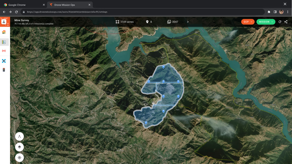
Clicks Mission Planning
Input flight parameters and let DMO handle the rest. Get ready-to-execute, optimized flight missions in seconds.
Smart Area Division
Missions divide vast areas into manageable sections. Plan 50,000+ acres in less than 10 seconds!

Organize Your Sites
Manage sites in collections. Say goodbye to clutter and manage projects better.

Pixel Perfect Maps
Automated Ground Control Point planning and custom terrain follow allow your drone maps to have the highest accuracy.

Minutes Data QC
On-field data quality check on DMO ensures that the data you capture is verified with 10+ comprehensive tests to ensure the best maps. All under 5 mins!
Video Call Your Drone
With low-latency livestream, 2 way communication and AI based analytics, you are never disconnected from the field. Go Live in 3 clicks!
Key Features
Advanced Mission Planning
- Intuitive mission planner with drag-and-drop functionality.
- Automated route creation and modification for optimal coverage.
- Geo-fencing capabilities to define no-fly zones and restricted areas.
Autonomous Flight Control
- Pre-programmed flight modes for automated missions.
- Real-time GPS-based navigation for accurate positioning.
- Intelligent obstacle detection and avoidance to ensure safe operations.
Precision Data Capture
- High-resolution aerial imaging and video capture.
- Multi-spectral and thermal imaging integration for diverse applications.
- Real-time data transmission for immediate analysis and decision-making.
User-friendly Interface
- Comprehensive dashboard for mission management.
- Real-time flight telemetry and status updates.
- Easy-to-use controls suitable for both beginners and experienced pilots.
Seamless Integration
- Compatibility with various drone hardware platforms.
- API support for third-party software integration.
- Support for industry-standard data formats for easy interoperability.
Enhanced Safety Protocols
- Automated emergency landing protocols and fail-safes.
- Continuous battery health monitoring with proactive alerts.
- Weather condition assessments and alerts to ensure safe flight operations.
Data Analytics and Reporting
- Advanced analytics tools for in-depth data analysis.
- Secure data storage with easy retrieval and sharing options.
- Detailed reporting features for post-mission review and documentation.
Collaboration and Team Management
- Multi-user access with customizable role-based permissions.
- Cloud-based data sharing for collaborative mission planning.
- Real-time coordination with ground teams and control centers.
Comprehensive Support and Maintenance
- Regular software updates and feature enhancements.
- Detailed user guides and tutorials for self-learning.
- Dedicated customer support for prompt assistance and troubleshooting.
Industry-specific Solutions
– Agriculture: Precision farming, crop monitoring, and yield estimation.
– Construction: Site surveying, progress tracking, and material management.
– Public Safety: Search and rescue, disaster assessment, and traffic monitoring.
– Environmental Monitoring: Wildlife tracking, pollution detection, and habitat mapping.


There are no reviews yet.