


Read More
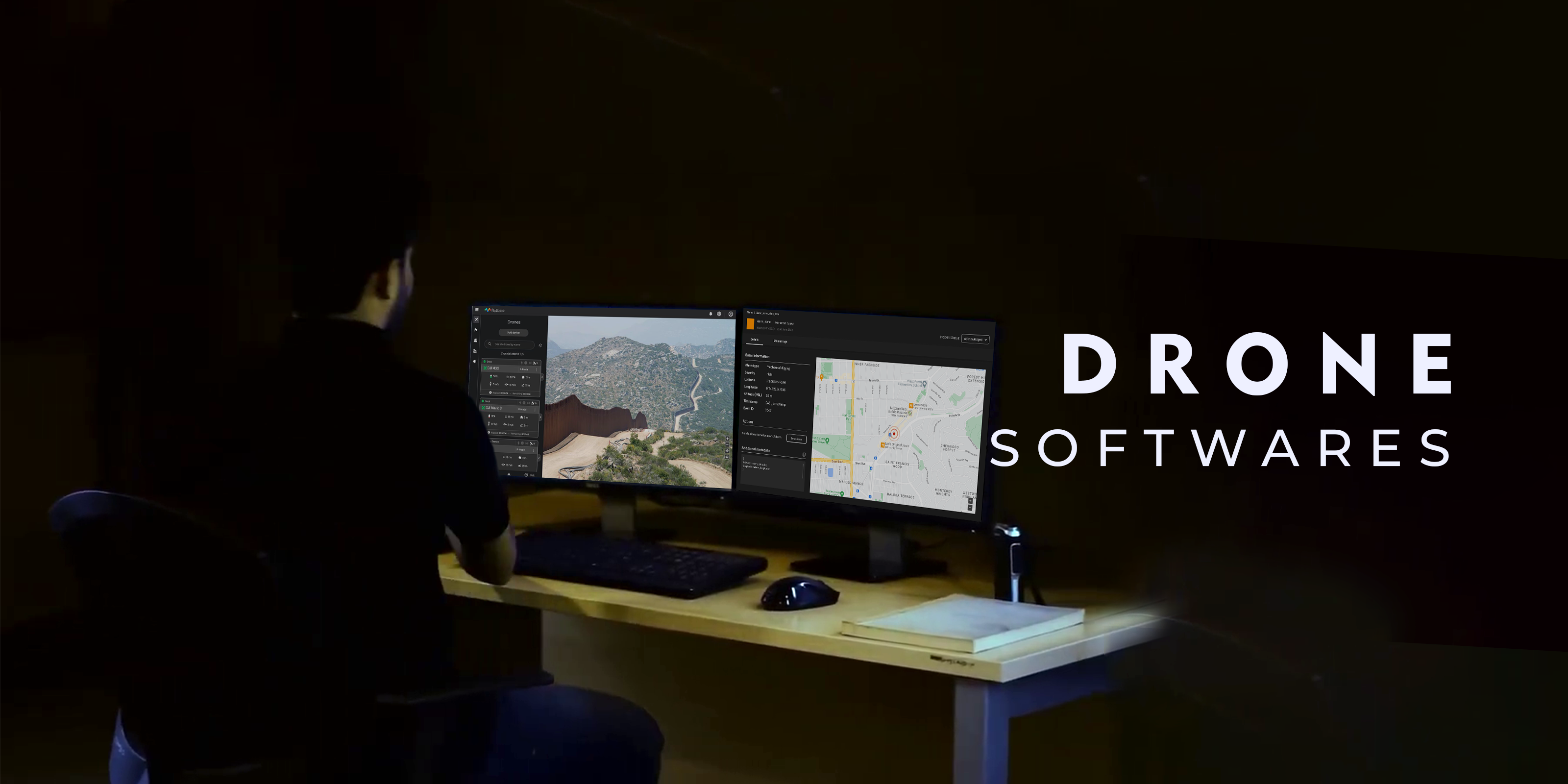
Discover Advanced Drone Software at Xboom: Elevate Your Aerial Capabilities
Explore top-tier Drone Software on Xboom. From DJI Terra to PIX4D, find the best software prices in India and optimize your drone operations with our professional solutions.
Introduction to Drone Software
In the ever-evolving landscape of aerial technology, it remains a crucial tool. It enhances the functionality and boosts the efficiency of drone operations. Therefore, Xboom.in proudly offers a comprehensive selection of advanced drone software. These tools are tailored to meet the needs of professionals across diverse industries. Whether you’re engaged in mapping, surveying, agriculture, or film production, the right software makes a difference. With it, you can transform aerial data into actionable insights and high-quality outputs.
Why Choose the Software?
It includes various applications that process drone-collected data effectively. It turns raw aerial imagery into detailed analytical reports and 3D models. Consequently, professionals use it for precise measurements and streamlined workflows. As a result, better decision-making becomes possible. At Xboom.in, we recognize the importance of powerful and reliable software. That’s why we feature industry-leading options like Metashape, DJI Terra, and PIX4D.
Featured Drone Software Solutions
DJI Terra: Optimize Your Operations
DJI Terra provides robust mapping capabilities that meet the needs of precision-driven industries. It suits construction, agriculture, and public safety applications. Consequently, users can generate real-time 3D models and accurate maps. This facilitates detailed analysis and continuous project monitoring.
PIX4D: Leading Photogrammetry Software
PIX4D leads in photogrammetry with software that transforms drone data into precise, georeferenced 2D maps and 3D models. Widely used in GIS, agriculture, and infrastructure, PIX4D delivers excellent results. Thus, professionals enhance project outcomes with accurate measurements and clear visualizations.
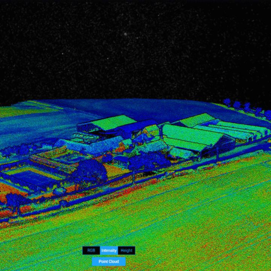
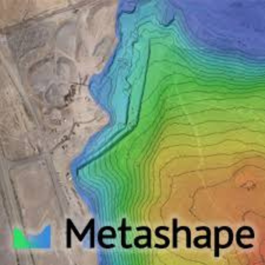
Metashape: Versatile Photogrammetry
Metashape receives acclaim for its robust image processing capabilities. It stitches photos into textured 3D models seamlessly. Because of this, it becomes ideal for cultural heritage documentation and visual effects production. Moreover, Metashape enables indirect measurements across varying object scales.
Buying Drone Software in India
Price in India
At Xboom.in, we provide competitively priced software to match industry needs. Therefore, you gain access to the latest tools affordably. Unlike other platforms, we eliminate unnecessary premium charges.
How to Choose the Right Software?
Choosing the right software depends on your project goals and drone type. First, consider compatibility with your drone model. Next, evaluate ease of use, processing speed, and output quality. Also, check available features. Our support team at Xboom gladly assists with any questions. Thus, you receive expert guidance and the right product.
Advantages of Professional Drone Software
Professional software simplifies complex aerial data into easy-to-use formats. Because of this, site inspections and progress tracking become more manageable. Also, you can estimate volume accurately. Equipped with photogrammetric processing and automatic point cloud classification, these tools offer excellent accuracy. As a result, professionals save time while maintaining precision.
Conclusion: Streamline Your Drone Operations with Advanced Software
The software redefines aerial technology. It delivers unmatched accuracy, boosts efficiency, and improves output quality. Hence, Xboom remains committed to offering top-tier software. Visit our platform today to explore our vast range of solutions. Choose the perfect software and elevate your operations to new heights.
FAQs
- What types of drone software are available on Xboom.in?
Xboom.in offers a variety of drone software solutions including DJI Terra, PIX4D, and Metashape, which cater to different professional needs such as mapping, photogrammetry, and data analysis. - How do I know which drone software is right for my needs?
The choice depends on your specific use case, such as agriculture, surveying, or cinematography. Consider the software’s compatibility with your drone, the complexity of the data processing, and the type of output you need. - Can I try the drone software before buying?
While Xboom.in does not directly offer trial versions, many software providers offer demo versions or trial periods. Check the specific product page for links to the manufacturer’s trial offers. - What are the system requirements for running drone software?
System requirements vary by software. Generally, you’ll need a modern PC with a powerful processor, ample RAM, and advanced graphics capabilities. Specific requirements can be found on the product detail pages on Xboom.in. - How does drone software improve drone operations?
It enables users to process aerial data into actionable insights, create detailed maps, perform volumetric measurements, and produce 3D models, enhancing productivity and accuracy in various applications. - Is technical support available for drone software purchased on Xboom?
Yes, Xboom.in provides customer support for all products sold on our platform, including assistance with installation, troubleshooting, and updates. - Are there any discounts available for purchasing multiple software licenses through Xboom?
Xboom occasionally offers discounts for bulk purchases or during promotional periods. Keep an eye on our website or subscribe to our newsletter for the latest deals. - What is the return policy for drone software purchased on Xboom?
Due to the digital nature of the software, returns may not be available. Please review our return policy on the website and check individual product pages for specific return information. - Can I use the software on multiple computers?
License terms vary by software. Some may allow installation on multiple devices, while others may be restricted to a single device. Check the licensing agreement of the purchased software for details. - How often do I need to update the drone software?
Software updates depend on the developer and the specific software version. It’s recommended to enable automatic updates if available, or check for updates regularly to ensure you have the latest features and security enhancements.
